-
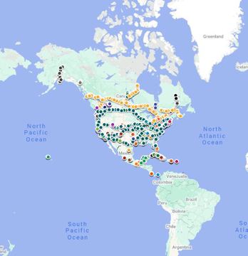
North American Transit google.com
Map of all Passenger Rail in North America including (intercity rail, metros, trams and tourist lines)
-
Google Earth google.com
Create and share custom maps with one of the the world's most detailed statelite applications.
-
Google Mymaps google.ca
Create and share custom maps with Google My Maps.
-
BusGraphs Access Analyzer gitlab.com
Web application for measuring the access provided by real and hypothetical fixed-route public transit networks, and visualizing and decomposing this access in variety of ways.
-
Offi Directions gitlab.com
An Android app that provides trip planning, schedules, live departure times, and disruption information for transport authorities in Europe and beyond.
-
Transi gitlab.com
A Cloud-native GTFS-RT/GTFS archiving system.
-
German Open Transport Meetup github.com
Biweekly online meetup of the German-speaking open transport community.
-
r-transit github.com
Collection of tools for GTFS in R.
-
transitcast github.com
Uses GTFS and GTFS-RT vehicle position feed generating an estimated transition time it takes for each vehicle to move from scheduled stop to scheduled stop recording these an "observed_stop_time" table. These records can later be used to train a machine learning model to make…
-
Open-Transport SYNTHESE Convertors github.com
Converts French-Transmodel, SIRI, NETeX, HAFAS, HASTUS, VDV452, and more.
-
SIRI API github.com
Java classes generated from the v1.0 and v1.3 SIRI schemas.
-
GTFS-realtime TripUpdates & VehiclePositions Producer Demo github.com
A Java-based demo project for producing GTFS-realtime TripUpdates (estimated arrivals) and Vehicle Positions.
-
SIRI to GTFS-realtime github.com
A Java-based command-line utility to convert from the SIRI format to GTFS-realtime.
-
NextBus API to GTFS-realtime github.com
A Java-based command-line utility to convert from the NextBus API format to GTFS-realtime. Note that NextBus now directly offers a GTFS-realtime API for their products. See Cubic site and this FAQ.
-
GTFS-realtime Exporter github.com
A Java-based tool that assists in producing and sharing a GTFS-relatime feed.
-
GTFS-realtime Alerts Producer Demo github.com
A Java-based demo project for producing GTFS-realtime Service Alerts.
-
OneBusAway GTFS Modules github.com
A Java-based library for reading, writing, and transforming public transit data in the GTFS format, including database support.
-
MaaS API github.com
A set of open documents and test suite that defines a MaaS-compatible API.
-
Home Assistant github.com
The General Transit Feed Specification (GTFS) integration was introduced in Home Assistant 0.17, and it's used by 70 active installations.
-
Transitfeed merge function github.com
A Python library with a function to merge two different GTFS feeds.
-
Google's feedValidator github.com
Google-supported Python-based GTFS validator.
-
GTFS-realtime documentation github.com
.
-
SIRI REST Client github.com
An open-source Android library for interacting with the RESTful SIRI interface for real-time transit data, such as that currently being used by the MTA Bus Time API.
-
OpenTripPlanner Android github.com
An Android app for OpenTripPlanner
-
SIRI 1.3 POJOs (Android-compatible) github.com
Android-compatible Plain Old Java Objects (POJOSs) used for data binding (deserliazing XML/JSON) responses for SIRI v1.3 APIs. Used by the SIRI REST Client.
-
King County Metro Legacy AVL to SIRI github.com
Java-based tool to convert King County Metro's Legacy AVL format to SIRI.
-
kml-to-gtfs-shapes github.com
Javascript tool to convert polylines from a KML file into a GTFS shapes.txt file. Hosted on GitHub here.
-
Transito git.sr.ht
FOSS data-provider-agnostic public transportation app that let's you route between locations using openly available public GTFS feeds (sourced from the Mobility Database). Utilizing the Mobroute Go API, the Transito app lets you performs routing calculations right on your…
-
OSMTransportViewer gileri.github.io
Use OSM Overpass API to get network data
-
RoutePress GTFS to GeoJSON Converter getroutepress.com
Free, easy-to-use browser tool that converts GTFS shapes and stops into GeoJSON for use in ArcGIS, QGIS, and other GIS software. No installation required.
-
DB InfraGO geovdbn.deutschebahn.com
Interactive Map of German Rail infrastructure.
-
GBFS gbfs.org
General Bikeshare Feed Specification: open data standard for real-time information about bikeshare, scootershare, mopedshare, and carshare.
-
Ferrocarta ferrocarta.net
A series of maps covering all of the passenger rail networks in Brazil, Canada and France.
-
European Railway Atlas europeanrailwayatlas.com
A reference book of European railway maps that is available for purchase.
-
Chouette enroute.atlassian.net
Converts between French-Transmodel NeTEX and GTFS.
-
El Tracker el-tracker.com
Realtime tracker for Chicago Transit Authority (CTA) Loop trains.
-
Bongo ebongo.org
Real-time Transit Tracking for Iowa City, Coralville and the University of Iowa. Combines three disparate transit systems into one UI.
-
Compares software tools for calculating accessibility by walking and public transit including ArcGIS Pro, Emme, R5R, and OpenTripPlanner.
-
RideSheet docs.ridesheet.org
A simple, spreadsheet-based tool for small demand-responsive transportation (DRT) services.
-
Entities Providing Transportation Software Development Consulting Services docs.google.com
Add new entities here.
-
Vendors Providing GTFS Creation/Maintenance services docs.google.com
Add new vendors here.
-
GTFS Realtime Prediction Accuracy metrics docs.google.com
Useful Performance Metrics for GTFS-Realtime.
-
Citymapper API docs.external.citymapper.com
REST API for transit journey planning, realtime transit data and walk, cycle, scooter travel times.
-
TripGo API developer.tripgo.com
REST API for multi-modal journey planning and real-time data by SkedGo.
-
HAFAS de.wikipedia.org
Propriety public transport management software by HaCon (list of endpoints)
-
DC MetroHero dcmetrohero.net
Realtime vehicle position and arrivals and departure information for the Washington, D.C. region's WMATA Metrorail and Metrobus systems. WebApp, Android, and iOS apps avaliable.
-
DATEX datex2.eu
EU data standard for road traffic and travel information.
-
gtfs-rt crates.io
Rust crate to read, write, and manipulate GTFS-Realtime data
-
Planetizen "Building a Transit Map Web App" course courses.planetizen.com
A video tutorial on setting up your own web-based mapping application, with no coding experience required.
-
GTFS Realtime Display codeberg.org
Analyse, monitor and maintain GTFS Realtime data. Example instances
- next page of items loading…