-
GTFS Display codeberg.org
Analyse, monitor and maintain GTFS data (Example instances).
-
message feed with Vehicle Position entities codeberg.org
in the GTFS-Realtime format or the Dede app can be used as data source/ as provider to the Dede server. The result is presented either on the Dede web front end or Dede display.
-
China Railway Map cnrail.geogv.org
An online Interactive map for the passenger railway transportation system of China, presenting station and rail information.
-
CityMapper Webapp citymapper.com
Really polished webapp with trip planner and route status for over 30 of cities.
-
CityMapper citymapper.com
-
Citylines.co citylines.co
A collaborative platform for mapping transit systems, with an emphasis on their historical evolution. The data can be downloaded as GeoJSON or CSV from citylines.co/data.
-
Catenary Maps catenarymaps.org
Realtime and Schedule global public transport map and navigation software, written in Rust and Svelte.
-
Carto.Metro cartometro.com
Detailed maps of metro and tram networks of global cities (especially in France).
-
Bustime busti.me
Public transport real-time monitoring with WebSocket updates. Open-source on GitHub.
-
Bus RT Insights busrtinsights.com
Web-based transit analytics platform that turns GTFS and GTFS-Realtime data into automated KPIs, service delivery analysis, load profiles, and interactive maps and dashboards for any agency that has GTFS and GTFS-RT publicly available.
-
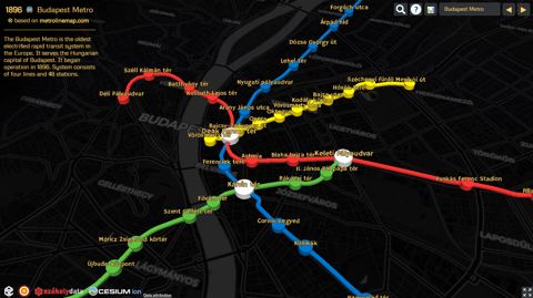
Metrocyclopaedia blog.csaladen.es
3d maps of metro systems across the world (uses data from Metrolinemap).
-
Chouette SaaS bitbucket.org
Tool to generate GTFS Schedule data
-
Ara SaaS bitbucket.org
Tool to generate GTFS Realtime data.
-
BISON bison.dova.nu
Netherlands implementation of SIRI.
-
Bing Maps Transit - Add your transit data to Bing Maps bing.com
Additional Bing-specific documentation of GTFS.
-
Bikeshare Map bikes.oobrien.com
Status of all worldwide bikeshare stations
-
BENO Metro Mapm Creator beno.uk
A very old fashioned but classic transit map creator.
-
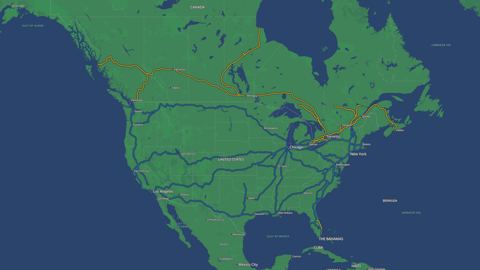
Intercity Rail map asm.transitdocs.com
Map of the real time location and schedule information for Amtrak and Via trains
-
SAE Shared and Digital Mobility Committee articles.sae.org
Appears to be working on a data standard for car share and transportation network companies (TNCs) / rideshare.
-
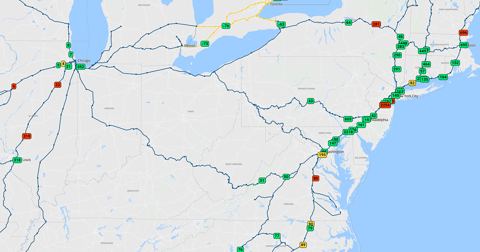
National Rail Network Map arcgis.com
This map shows the extent and ownership of rail lines in the United States, including passenger and freight lines.
-
APTA Policy Development and Research - Public Transportation Embracing Open Data apta.com
APTA's discussion of the benefits and challenges of open transit data (a short summary of the below TCRP report).
-
NCHRP 08-119 apps.trb.org
The objective of this research is to develop standards and/or guidance to be used and adopted by the transportation community in collecting, managing, and sharing static and real-time data for transportation planning and operations.
-
TCRP G-16 apps.trb.org
The objective of this research is to develop technical specifications for transactional data for entities involved in the provision of demand-responsive transportation. Expected completion date is late 2018.
-
SEPTA Rail OTP Report apps.phor.net
An online on-time performance reporing & drill down tool using GTFS.
-
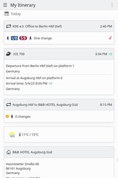
KDE Itinerary apps.kde.org
App (Desktop and Android) for planning trips. It can find public transport routes, store them offline, add events to your trips, see the floor plan of train stations, and much more. Souce Code, GitHub
-
CityBikes api.citybik.es
REST API for aggregated bikeshare data from around the world. Powered by pyBikes.
-
Bus Observatory API api.busobservatory.org
Public archive of real-time data on vehicle movements and status, collected from transit systems around the world.
-
Amtraker amtraker.com
Live tracker for Amtrak trains across the US, with route maps and station ETAs.
-
AllRailMap allrailmap.com
Another worldwide map of railways using OpenStreetMap data.
-
APDS allianceforparkingdatastandards.org
Alliance for Parking Data Standards: formed by the International Parking Institute (IPI), the British Parking Association (BPA), and the European Parking Association (EPA). APDS is a not-for-profit organization with the mission to develop, promote, manage, and maintain a…
-
All Transit all-transit.com
Interactive GTFS route and schedule animation (for U.S. cities) using Mapbox GL JS, Deck.gl and Transitland. Github repository here.
-
Tramscale alexander.co.tz
Website outlining maps showing the scales of tram systems around the world.
-
Timelines alexander.co.tz
Compare the timelines of Rapid Transit Projects around the world.
-
Adobe illustrator adobe.com
The industry-leading vector graphics software (requres membership plan).
-
AddTransit addtransit.com
SaaS (Software as a Service) platform to create, edit and publish schedules in GTFS format.
-
"How to use GTFS data to track transit vehicles in realtime" by Tom Camp ably.io
Using GTFS and GTFS Realtime to provide continuous realtime updates.
-
Tree Canopy data.fs.usda.gov
The U.S. Forest Service (USFS) Geospatial Technology and Applications Center (GTAC) builds and maintains tree canopy cover (TCC) datasets.
-
BTS Open Data Site data-usdot.opendata.arcgis.com
On the BTS Open Data site, browse geospatial data that is part of the BTS National Transportation Atlas Database (NTAD) product. NTAD is a set of nationwide (United States) geographic databases of public spatial information for transportation facilities and networks; flows of…
-
Data Axle data-axle.com
Offers some of the most comprehensive and accurate business and consumer databases, boasting almost 400 distinct attributes across businesses and consumers in the United States and Canada.
-
Transit Equity Dashboards dashboard.transitcenter.org
Equity analysis of transit systems in seven (and counting) US cities, published by TransitCenter.
-
Dash dash.plotly.com
An open source Python library for building interactive data visualizations on the web. It enables you to build custom data dashboards using pure Python.
-
Cyclomedia cyclomedia.com
Captures accurate visual data including imagery and LIDAR at street level and transforms it into valuable insights.
-
CyberCity3d cybercity3d.com
Offers a diverse range of digital city models from stereo imagery and keeps an extensive library in 130 cities.
-
CurbLR curblr.org
An open data specification for curb regulations maintained by SharedStreets. Additional Information: GitHub, Demo: Interactive map and example feed, Blog post: Why CurbLR was built.
-
curbFlow curbflow.com
Computer vision based services to quantify events occurring in the built environment affordably and quickly.
-
CTPP ctpp.transportation.org
The CTPP Program procures tabulations of American Community Survey (ACS) 5-year (and historical Census decennial) data. The chief differences between ACS data and CTPP data are FLOWS from home to work and WORKPLACE BASED data at small Geographies.
-
Tmap cran.r-project.org
Thematic maps are geographical maps in which spatial data distributions are visualized. This package offers a flexible, layer-based, and easy to use approach to create thematic maps, such as choropleths and bubble maps.
-
tidytransit cran.r-project.org
A tidy approach to accessing and manipulating GTFS data, including transit routes, schedules, and stops.
-
tidytext cran.r-project.org
Go-to library for text mining--often used in tandem with ggplot or other text mining libraries.
-
stplanr cran.r-project.org
Tools for transport planning with an emphasis on spatial transport data and non-motorized modes including OD data processing and other functions.
- next page of items loading…