Higgins et al. - "Calculating place-based transit accessibility: Methods, tools and algorithmic dependence" (2022)
Compares software tools for calculating accessibility by walking and public transit including ArcGIS Pro, Emme, R5R, and OpenTripPlanner.
- from
- Transit
- added
- 2026-10-10
- likes
- 0
similar
-
MIT COAXS mittransportanalyst.github.io
Co-creative Planning of Transit Corridors using Accessibility-Based Stakeholder Engagement (shows route scenarios using OpenTripPlanner Analyst).
-
ESRI ArcGIS Public Transit Tools (GTFS) github.com
Tools for working with public transit data in ArcGIS
-
BusGraphs Access Analyzer gitlab.com
Web application for measuring the access provided by real and hypothetical fixed-route public transit networks, and visualizing and decomposing this access in variety of ways.
-
Transito git.sr.ht
FOSS data-provider-agnostic public transportation app that let's you route between locations using openly available public GTFS feeds (sourced from the Mobility Database). Utilizing the Mobroute Go API, the Transito app lets you performs routing calculations right on your…
-
Toronto Transit Explorer github.com
A Java application that visualizes transit, biking and walking accessibility across the city of Toronto. Uses a modified version of R5 for routing.
-
Aemmer et al. - "Measurement and classification of transit delays using GTFS-RT data" link.springer.com
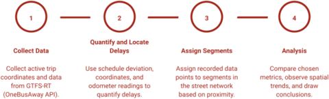
Presents a method for extracting transit performance metrics from a General Transit Feed Specification’s Real-Time (GTFS-RT) component and aggregating them to roadway segments. Used with Transit Vis, viewable here.

Transit › Resources > Research and Commentary > Academic papers: “Compares software tools for calculating accessibility by walking and public transit including ArcGIS Pro, Emme, R5R, and OpenTripPlanner.”