Miscellaneous
17,439 items in 132 lists
-
MetroDreamin' metrodreamin.com
A modern, open source software that allows users to create, save, like, and share interactive transit maps with agents.
-
Britsh Railways merrittcartographic.co.uk
An interactive map of Great Britain's rail network.
-
"Visualizing Better Transportation: Data & Tools" by Steve Pepple medium.com
A collection of transportation-related data and tools for the San Francisco Bay Area and other cities in North America, originally collected and discussed at a 2018 Transit Week Event at ARUP in San Francisco.
-
"What's new in GTFS-realtime v2.0" by Sean Barbeau medium.com
Discuss the shortfalls in GTFS-realtime v1.0 and the improvements in v2.0.
-
"GTFS Best Practices now available!" by Sean Barbeau medium.com
Discusses some of the challenges of an open data format like GTFS and the GTFS Best Practices that were launched in early 2017 to help address data quality.
-
Visualizing MBTA Data mbtaviz.github.io
Interactive graphs that show how people use Boston's subway system.
-
Mapnificent mapnificent.net
Shows areas you can reach with public transport in a given time. Open-source on GitHub, live at https://www.mapnificent.net/.
-
Railway Stations map.railway-stations.org
Photos of Railway Stations across the world.
-
RailFansCanada map.railfans.ca
Interactive System Map detailing the the present and future of different urban rail systems in Canada.
-
Local Transit localtransit.app
Map visualization of public transit frequency, created using QGIS.
-
Linked Connections linkedconnections.org
An open-source, scalable intermodal route planning engine, which allows clients to execute the route planning algorithm (as opposed to the server). Uses GTFS data.
-
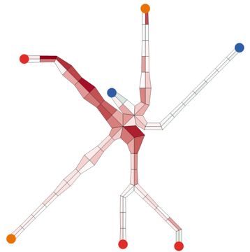
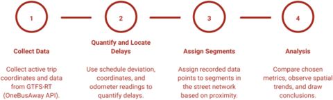
Aemmer et al. - "Measurement and classification of transit delays using GTFS-RT data" link.springer.com
Presents a method for extracting transit performance metrics from a General Transit Feed Specification’s Real-Time (GTFS-RT) component and aggregating them to roadway segments. Used with Transit Vis, viewable here.
-
SIRI 2.0 Autodoc laidig.github.io
Automatically generated documentation from the (incredibly well) annotated SIRI 2.0 Schema Definition.
-
GTFS-realtime Autodoc laidig.github.io
Automatically generated documentation for GTFS-realtime, generated from the official GTFS-realtime protocol buffer specification and including some extensions.
-
"Legacy AVL system? It's okay, join the club." by Kurt Raschke kurtraschke.com
Discussion of options for transforming legacy AVL system data into the GTFS-realtime format.
-
Unroll jungle-bus.github.io
Public transport routes
-
Jungle Bus Map jungle-bus.github.io
A webmap for viewing transport stop deails in OpenStreetMap.
-
JR pass jrpass.com
Interactive Map of Mainline Rail in Japan.
-
Brand New Subway jpwright.github.io
An interactive transportation planning game that lets players alter the NYC subway system to their heart's content.
-
JOSM Validator Rules josm.openstreetmap.de
The JOSM validator (Tag checker) can be customized with different rules based on MapCSS.
-
UK2GTFS itsleeds.github.io
R package that converts UK format TransXchange (bus, metro, tram, ferry) and CIF (rail) timetables to GTFS.
-
Is SEPTA Fucked? isseptafucked.com
Status dashboard for SEPTA (Philadelphia) showing whether Regional Rail, Metro, and bus service is currently disrupted.
-
Is Metro Burning? ismetroburning.com
Similar at-a-glance status board for WMATA (D.C. Metro).
-
KPublicTransport invent.kde.org
A C++ library for accessing realtime public transport data and for performing public transport journey queries.
-
Indian Railways Map indiarailinfo.com
Interactive Maps of the Indian Main rail network.
-
INAT inat.fr
Aesthetically pleasing static maps of worldwide metros systems.
-
haltestelle.net haltestelle.net
Live departure boards for every stop in Germany's VRR and VRS transit networks (Rhine-Ruhr / Rhine-Sieg, NRW), powered by the TRIAS realtime interface. Also shows live vehicle positions along each line and real-time elevator/escalator status — runs entirely in the browser, no…
-
GTFS-to-HTML gtfstohtml.com
Generate human-readable timetables in HTML or PDF format directly from GTFS.
-
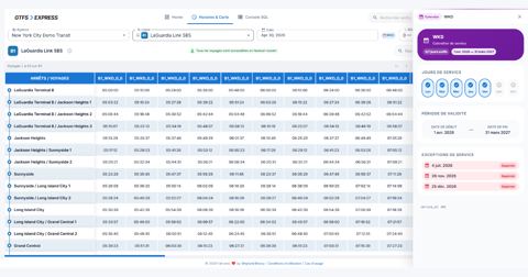
GTFS Express gtfsexpress.com
Web application to edit, validate and analyze GTFS feeds — including Fares v2 and GTFS-Flex — with an interactive schedule grid and map editor, an SQL console with AI-assisted natural-language queries, and strict canonical validation via MobilityData's gtfs-validator.
-
GTFS Studio gtfs.studio
Online editor for GTFS feeds
-
GTFS.html gtfs.pleasantprogrammer.com
An entirely browser-based tool to view GTFS feeds. Use it to view routes, stops, timetables, etc.
-
GTFS.org gtfs.org
official documentation site for the General Transit Feed Specification.
-
GTFS.guru gtfs.guru
Rust-core GTFS validator that compiles to WebAssembly so feeds can be validated locally in the browser. Also ships desktop apps, a CLI, and Python bindings.
-
OneBusAway Developers mailing list groups.google.com
-
OneBusAway API mailing list groups.google.com
-
TXC TransXChange publisher (UK Department for Transport) gov.uk
The TXC TransXChange publisher is a standalone software tool that can be used to publish TransXChange compliant XML documents in a format that’s easy to read and print.
-
Swiftly goswift.ly
Tool generate realtime transit data.
-
North American Transit google.com
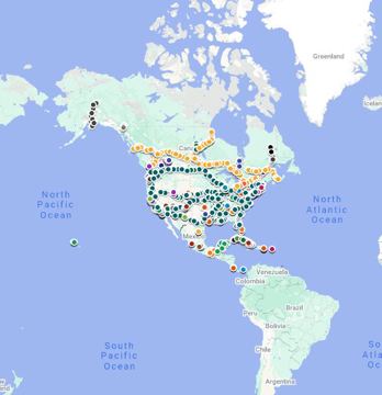
Map of all Passenger Rail in North America including (intercity rail, metros, trams and tourist lines)
-
Google Earth google.com
Create and share custom maps with one of the the world's most detailed statelite applications.
-
Google Mymaps google.ca
Create and share custom maps with Google My Maps.
-
BusGraphs Access Analyzer gitlab.com
Web application for measuring the access provided by real and hypothetical fixed-route public transit networks, and visualizing and decomposing this access in variety of ways.
-
Offi Directions gitlab.com
An Android app that provides trip planning, schedules, live departure times, and disruption information for transport authorities in Europe and beyond.
-
Transi gitlab.com
A Cloud-native GTFS-RT/GTFS archiving system.
-
German Open Transport Meetup github.com
Biweekly online meetup of the German-speaking open transport community.
-
r-transit github.com
Collection of tools for GTFS in R.
-
Open-Transport SYNTHESE Convertors github.com
Converts French-Transmodel, SIRI, NETeX, HAFAS, HASTUS, VDV452, and more.
-
SIRI API github.com
Java classes generated from the v1.0 and v1.3 SIRI schemas.
-
GTFS-realtime TripUpdates & VehiclePositions Producer Demo github.com
A Java-based demo project for producing GTFS-realtime TripUpdates (estimated arrivals) and Vehicle Positions.
-
SIRI to GTFS-realtime github.com
A Java-based command-line utility to convert from the SIRI format to GTFS-realtime.
-
NextBus API to GTFS-realtime github.com
A Java-based command-line utility to convert from the NextBus API format to GTFS-realtime. Note that NextBus now directly offers a GTFS-realtime API for their products. See Cubic site and this FAQ.
- next page of items loading…