-
USALEEP cdc.gov
Estimates of life expectancy at birth—the average number of years a person can expect to live—for most of the census tracts in the United States for the period 2010-2015.
-
CARTO carto.com
A world leading Location Intelligence platform, enabling organizations to host & use spatial data and enable analysis for more efficient delivery routes, better behavioural marketing, strategic store placements, and much more.
-
National Noise Map bts.gov
Data within the National Transportation Noise Map represent potential noise levels across the nation for an average annual day for the specified year.
-
Bureau of Labor Statistics bls.gov
The Bureau of Labor Statistics measures and provides access to data on labor market activity, working conditions, price changes, and productivity in the U.S. economy to support public and private decision making.
-
University of Oregon, AI Software List blogs.uoregon.edu
A blog cataloguing existing AI resources compiled by university researchers and local policy experts.
-
bangthetable bangthetable.com
Provides access to a platform that centralizes community engagement, making it easy to capture, analyze, and report on city-wide engagement through one single platform.
-
Automotus automotus.co
Computer vision based platform that helps cities, airports, fleets, and businesses monitor the curb in real time. Enables curbside management policies that increase revenue while making streets less congested, more sustainable, and more equitable.
-
Forma autodesk.com
Autodesk Forma is a cloud based platform that enables architects and designers to conduct pre-design and schematic design evaluations and environmental impact simulations.
-
CDC Social Vulnerability Index atsdr.cdc.gov
This dataset uses 15 U.S. census variables to help local officials identify communities that may need support before, during, or after disasters based on their level of social vulnerability. Additional Information: Download.
-
OpenDrive asam.net
The data that is stored in an ASAM OpenDRIVE file describes the geometry of roads, lanes and objects, such as roadmarks on the road, as well as features along the roads, like signals.
-
Arkio arkio.is
A new cloud-based collaborative spatial design software that allows planners, designers, and stakeholders to create 3-D models of buildings and neighborhoods over VR and other devices.
-
ArchiWise archiwise.ai
AI-powered real estate pre-development and site selection platform that helps developers, architects, brokers, and planning consultants analyze zoning, feasibility, and site data quickly.
-
STEAP arcgis.com
The Screening Tool for Equity Analysis of Projects (STEAP) is a census sampling tool that allows rapid screening of potential project locations anywhere in the United States to support Title VI, environmental justice, and other socioeconomic data analyses.
-
Anthropic anthropic.com
Provides access to a class of advanced large language models called Claude designed to provide human-like text responses and engage in conversational interactions.
-
AirSage airsage.com
A well-known provider of location based services and GPS data from cell phones operating in the space since 2000.
-
Adobe Creative Suite adobe.com
Adobe's collection of 20+ desktop and mobile apps and services for photography, design, video, web, UX, and more. Popular products include Photoshop, Adobe Illustrator, and others.
-
Adaptbase adaptbase.us
This knowledge graph resource seeks to organize the worlds climate adaptation knowledge based on climate publications from a range of resources. Enables the ability to look at adaptation by topic, city, or system.
-
Adaptation Clearinghouse adaptationclearinghouse.org
Maintained by Georgetown's Climate Center, this is an extensive online database and networking site that serves policymakers and others who are working to help communities adapt to climate change.
-
Accessibility Observatory access.umn.edu
As part of the Access Across America series the Accessibility Observatory at UMN evaluates multiple modes of transportation accessibility in major U.S. metropolitan areas. Reports are published annually, and select data sets are available through the University of Minnesota's…
-
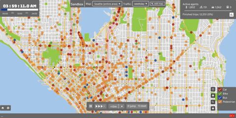
A/B Street abstreet.org
Edit streets and intersections, explore the effects through traffic simulation on all modes, and use the resulting visualizations to communicate a proposal. Apache licensed, runs anywhere with OpenStreetMap, and works on the web or as an offline download.
-
99% Invisible 99percentinvisible.org
A sound-rich, narrative podcast about all the thought that goes into the things we don't think about — the unnoticed architecture and design that shape our world.
-
3D Street 3dstreet.org
An open-source 3D street design and virtual reality application that allows users to directly import their street designs from Streetmix into an interactive 3D web scene. Apart from the community version, it also provides a Pro version with integration with Google Earth and…
-
CMD markdown zybuluo.com
-
Zotero Style Repository zotero.org
-
Mathematica Online wolfram.com
-
white noise mp3s whitenoisemp3s.com
-
White.Noise whitenoise247.net
-
wakari.io wakari.io
-
Voidly Censorship Index voidly.ai
-
US Virtual Astronomical Observatory usvao.org
-
Unpay Wall unpaywall.org
-
QR Code Generator unitag.io
-
Uncited uncited.org
-
Font Catalogue tug.dk
-
TitleCap titlecapitalization.com
-
Iris.ai the.iris.ai
-
Tadam tadamapp.com
-
Sway sway.com
-
jsmind sourceforge.net
-
Soundrown soundrown.com
-
Slideas slideas.app
-
Muji Sleep sleep.muji.net
-
BoxPlotR shiny.chemgrid.org
-
Color Calculator sessions.edu
-
SEQanswers seqanswers.com
-
De-Jargonizer scienceandpublic.com
-
Bootstrap theme ryan-roemer.github.io
-
Rust rust-lang.org
-
Reproduced Papers reproduced-papers.github.io
-
Mathematica slides reference.wolfram.com
- next page of items loading…